 hadhwanaag
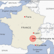
A 5.6 magnitude
earthquake left more than 260 dead and hundreds injured as buildings crumbled
and terrified residents ran for their lives on Indonesia's main island of Java.
Bodies continued to be
pulled from the debris on Tuesday morning in the hardest-hit city of Cianjur,
located in the country's most densely populated province of West Java and some
217 kilometers (135 miles) south of the capital, Jakarta. A number of people
are still missing.
While the magnitude
would typically be expected to cause light damage to buildings and other
structures, experts say proximity to fault lines, the shallowness of the quake
and inadequate infrastructure that cannot withstand earthquakes all contributed
to the damage.
Here's a closer look at the earthquake
and some reasons why it caused so much devastation:
Was Monday's
earthquake considered "strong"?
The U.S. Geological Survey said the quake late Monday afternoon
measured 5.6 magnitude and struck at a depth of 10 kilometers (6.2 miles).
Quakes of this size usually don't cause widespread damage to
well-built infrastructure. But the agency points out, "There is not one
magnitude above which damage will occur. It depends on other variables, such as
the distance from the earthquake, what type of soil you are on, building
construction" and other factors.
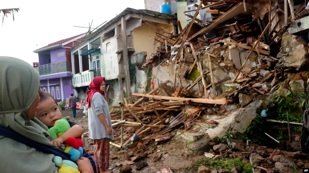
Dozens of buildings were damaged in Indonesia, including Islamic
boarding schools, a hospital and other public facilities. Also damaged were
roads and bridges, and parts of the region experienced power blackouts.
So why did the
quake cause so much damage?
Experts said proximity to fault lines, the depth of the temblor
and buildings not being constructed using earthquake-proof methods were factors
in the devastation.
"Even though the earthquake was medium-sized, it (was)
close to the surface ... and located inland, close to where people live,"
said Gayatri Marliyani, an assistant geology professor at Universitas Gadjah
Mada, in Yogyakarta, Indonesia. "The energy was still large enough to
cause significant shaking that led to damage."
The worst-affected area is close to several known faults, said
Marliyani.
A fault is a place with a long break in the rock that forms the
surface of the earth. When an earthquake occurs on one of these faults, the
rock on one side of the fault slips with respect to the other.
"The area probably has the most inland faults compared to
the other parts of Java," said Marliyani.
She added that while some well-known faults are in the area,
there are many other active faults that are not well studied.
Many buildings in the region are also
not built with quake-proof designs, which further contributed to the damage,
said Danny Hilman Natawidjaja, an earthquake geology expert at the Indonesian
Institute of Sciences Geotechnology Research Center.
"This makes a quake of this size and depth even more
destructive," he said.
Does Indonesia
usually have earthquakes like this?
The country of more than 270 million people is frequently struck
by earthquakes, volcanic eruptions and tsunamis because of its location on the
arc of volcanoes and fault lines in the Pacific Basin known as the "Ring
of Fire." The area spans some 40,000 kilometers (25,000 miles) and is
where a majority of the world's earthquakes occur.
Many of Indonesia's earthquakes are minor and cause little to no
damage. But there have also been deadly earthquakes.
In February, a magnitude 6.2 earthquake killed at least 25
people and injured more than 460 in West Sumatra province. In January 2021, a magnitude
6.2 earthquake killed more than 100 people and injured nearly 6,500 in West
Sulawesi province.
A powerful Indian Ocean quake and tsunami in 2004 killed 230,000
people in a dozen countries, most of them in Indonesia.
VOA
Hadhwanaagnews marnaba masuul kama aha Aragtida dadka kale. Qoraaga ayaa xumaanteeda, xushmadeeda iyo xilkeeda sida. waxa kaliya oo Hadhwanaagmedia dhiirigalinaysaa, isdhaafsiga aragtida, canaanta gacaliyo talo wadaagga!